El Niño could bring wetter fall weather to the Cape Fear
WILMINGTON, N.C. — After a summer marked by prolonged heat and drought, the Cape Fear could see a much wetter weather pattern this fall as El Niño strengthens.
Meteorologist Tim Armstrong said the shift could become more noticeable later in the season as cold fronts and low-pressure systems become more common.
“As we move into late fall and cold fronts and passing low pressure systems become more common El Niño tends to feed additional moisture,” Armstrong said.
That additional moisture could increase rainfall across the region.
“This extra moisture can bring higher rainfall totals across the southeast U.S.,” Armstrong said.
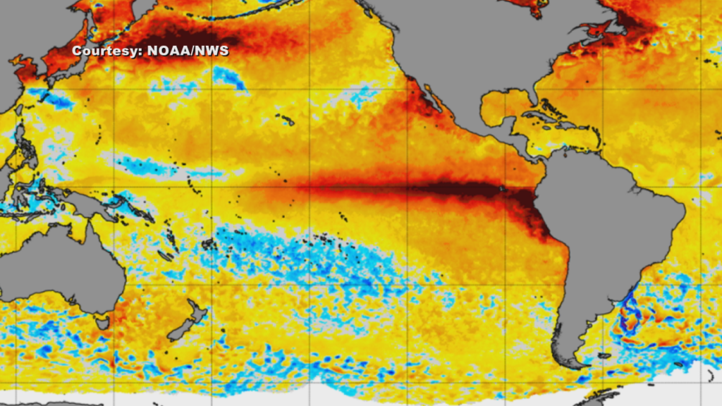
Meteorologist Brandon Locklear says El Niño begins thousands of miles away in the tropical Pacific Ocean, where water temperatures near the equator become warmer than normal.
“The waters are actually warmer than normal in the equatorial, uh, tropical Pacific. And what that ends up doing is it actually changes where the convection and rainfall is occurring over the equatorial Pacific, and that changes the jet stream,” Locklear said.
The jet stream is a fast-moving current of air high above the Earth that helps steer weather systems. Changes in its position can determine where storms travel and which areas experience more rain, heat or colder air.
Locklear said El Niño typically positions the jet stream farther south during the colder months.
“In the wintertime for us, the jet stream’s kind of sitting right over southeastern portions of the United States, which typically means wetter-than-normal conditions,” Locklear said.
The jet stream stayed farther north for much of the summer, contributing to a stretch of hot and dry weather across the Cape Fear. Temperatures repeatedly climbed into the 90s as crops and soil dried out and drought conditions worsened.
Klaus Albertin, chair of the North Carolina Drought Management Council, said the conditions led to water conservation efforts in some communities.
“Water on even days or odd days depending on their address no car washing on hard surfaces that just end up running off into the street and evaporating, drip irrigation that puts a little at each plant so you’re not wasting a lot of water,” Albertin said.
The weather pattern began changing in August as the jet stream moved closer to the Cape Fear. Wilmington received about 15 inches of rain during the month, making it the second-wettest August on record.
Forecasters say El Niño is continuing to strengthen.
“El Nino is still growing in strength and is expected to become one of, if not the strongest observed since modern records began in 1950,” Armstrong said.
Along with increased chances for rainfall, the Climate Prediction Center is calling for a greater chance of above-normal temperatures across the region this fall. The warmer outlook is also influenced by long-term warming trends associated with climate change.