Near record temperatures expected today
(WWAY) — Temperatures will reach into the upper 80s today with the hot weather continuing this weekend.
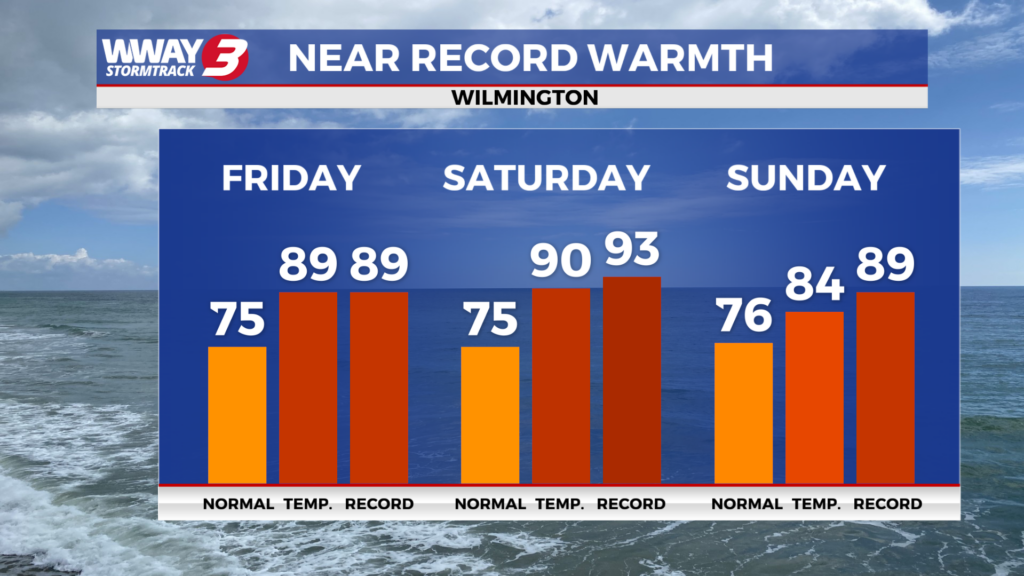
Today and Saturday we expect plentiful sunshine and a few clouds as high temperatures soar to near record and unseasonable levels reaching the upper 80s to around 90. The daily record is 89 today set back in 2006 and 93 Saturday set back in 1976. Sunday a cold front advances toward the region bringing partly cloudy skies with a possibility of a few showers or a thunderstorms mainly in the afternoon and evening… with some areas getting nothing and others perhaps getting a tenth or two tenths of rain. Highs will reach the middle 80s Sunday. Behind this front next Monday… noticeably cooler air will move in with mostly sunny skies. Lows will bottom out in the upper 40s with afternoon highs around 70. High pressure fully dominates next Tuesday bringing plentiful sunshine with chilly lows in the mid to upper 40s and afternoon highs in the lower 70s. The high pressure continues to dominate but shifts offshore next Wednesday leading to mostly sunny skies and milder highs in the upper 70s to near 80. More dry weather lingers next Thursday with a good deal of sunshine and warm highs in the lower 80s. Low rainfall totals (some areas get none) are expected over the next 7 days and with severe drought in place… be very careful with flame and heed the North Carolina statewide burn ban in place. Also… water conservatively.
WWAY FORECAST:
Today: Mostly sunny and rather hot. A near record high in the upper 80s to near 90. Winds southwest at 10-15 mph.
Tonight: Mostly clear and mild. Low again in the lower to mid 60s.
Saturday: Abundant sunshine mixed with a few clouds. Continued rather hot with a high around 90.
Sunday: Mostly cloudy skies with a chance of rain with temperatures into the middle 80s.
-Meteorologist Jason Korver