Increasing temperatures expected for 4th of July
(WWAY) — Temperatures will be right near the average for today as temperatures increase for the upcoming holiday weekend.
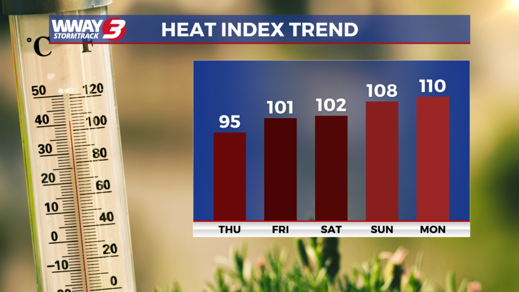
High pressure remains the main weather feature again today with abundant sunshine and a few clouds locally and highs reaching the lower 90s. Our pattern changes by the end of the week and into the holiday weekend as a strong upper-level ridge brings high heat and moderate humidity under rain-free skies. Look for mostly sunny skies with highs Friday in the middle 90s and middle to upper 90s for highs by Independence Day Saturday. Heat indices will reach as high as 100-104 Friday but could soar over 105 in some spots Saturday. Heat exhaustion or heat stroke could occur with these type numbers and with many outside for the holiday… take breaks in the AC… stay hydrated and wear loose fitting and light-colored clothing. By Sunday a surface trough in the Carolinas could bring a return to isolated showers or thunderstorms otherwise it will remain very hot and humid with highs in the mid to upper 90s along with heat indices 106-110. Next Monday… the good news is a little better coverage of showers and thunderstorms works back into the region hopefully bringing some much-needed rainfall… however it will still be very hot with highs in the upper 90s and triple digit heat indices. Next Tuesday a surface trough just to our west will bring widely scattered showers and thunderstorms along with hot and humid highs in the middle 90s.
WWAY FORECAST:
Thursday: Abundant sunshine and a few clouds. Rather hot afternoon with a high in the lower 90s. Heat indices in the afternoon reaching as high as the mid 90s. Winds light becoming southeast at 5-10 mph.
Thursday Night: Fair skies. Warm and muggy low in the lower 70s.
Friday: Mostly sunny… hot and humid. High in the middle 90s. Heat indices in the afternoon reaching as high as 100-104.
Saturday(Independence Day): Mostly sunny with hot and humid weather. temperatures into the middle to upper 90s. Heat index values could reach above 105 in some spots.
-Meteorologist Jason Korver