Cold snap to bring risk of freezing temperatures and frost to Cape Fear region this weekend
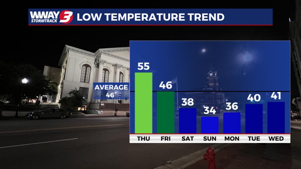
WILMINGTON, NC (WWAY) — The Cape Fear region is preparing for a significant drop in temperatures this weekend, with freezing conditions and frost possible across southeastern North Carolina.
According to the Wilmington’s National Weather Service and WWAY meteorologists, a series of cold fronts will bring much colder and drier air into the region beginning Friday, with the greatest potential for freezing temperatures Saturday night into Sunday morning.
Temperatures could fall to levels more typical of mid-January, with overnight lows dipping into the lower 30s across inland communities.
Mild weather before temperatures plunge
Veterans Day will remain mild, with a mix of clouds and sunshine and afternoon highs in the mid-70s.
WWAY Meteorologist Cicily Hammers says Thursday will bring another warm day, with temperatures climbing into the mid-to-upper 70s.
Breezy conditions are expected ahead of an approaching cold front, but rain chances will remain very low.
The National Weather Service says the first front will move through Thursday, followed by another front Friday that will usher in significantly colder air.
Frost and freezing temperatures possible this weekend
By Friday, afternoon highs are expected to struggle to reach the upper 50s, with similar temperatures continuing through the weekend.
Overnight temperatures will fall into the 30s, with the coldest conditions expected Saturday night into Sunday morning.
The National Weather Service says the risk of a widespread freeze is increasing for inland areas Saturday night and Sunday night.
Communities closer to the coast may remain slightly warmer, although frost is still possible.
A Freeze Watch could become necessary for areas away from the immediate coastline.
The colder temperatures are expected to continue into early next week.
Residents encouraged to protect plants
With the first significant cold snap of the season approaching, residents are encouraged to prepare now.
Our meteorologists recommend bringing potted plants indoors, covering sensitive vegetation and taking precautions to protect plants from frost and freezing temperatures.
Although sunshine is expected to return this weekend, temperatures will remain well below normal.
Breezy conditions possible along the coast
The National Weather Service also expects winds to increase Thursday as the first cold front moves through.
Gusts could approach 25 knots over portions of the North Carolina coastal waters, potentially requiring a brief Small Craft Advisory.
Seas could reach 2 to 5 feet in coastal waters and 5 to 8 feet farther offshore Thursday before gradually subsiding.
As of Wednesday morning, the National Weather Service reported no active weather alerts for the region.
Residents can monitor the latest forecasts and potential frost or freeze alerts through WWAY’s weather page, WWAY’s StormTrack 3 app, and the National Weather Service in Wilmington.