ECU archaeologists reveal new details about shipwrecks at Brunswick Town Historic Site
WINNABOW, NC (WWAY) — A team of archaeologists with East Carolina University’s Program in Maritime Studies recently discovered multiple shipwrecks and colonial waterfront features at Brunswick Town/Fort Anderson State Historic Site (BTFA) in Brunswick County, North Carolina.
“We are extremely excited about these important sites, as each one will help us to better understand the role of BTFA as one of the state’s earliest colonial port towns,” said Dr. Jason Raupp, assistant professor in the Department of History and maritime studies, who led the team. “These submerged colonial waterfront features are incredibly well-preserved and present an excellent opportunity for ECU students to engage in hands-on, collaborative research.”
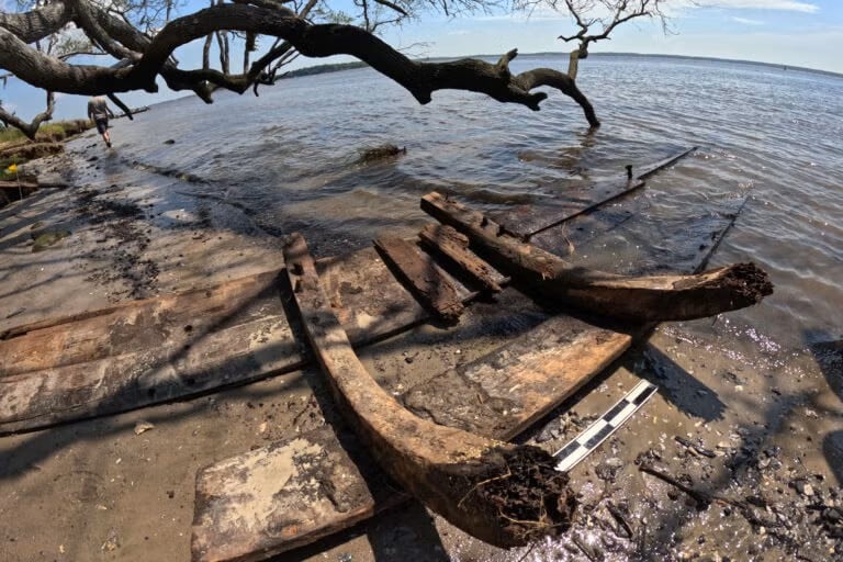
In May and June, ECU archaeologists recorded four newly discovered shipwrecks along the BTFA shoreline. Wood species samples collected from one wreck indicate that some of the wood used in its construction was sourced from either Monterey cypress (H. macrocarpa) or Mexican cypress (H. lusitanica). The historical range of this wood species is limited to southern California and Central America, respectively, which suggests that shipbuilders incorporated raw materials from Spanish Caribbean colonies in the 18th century.
As the only historically reported shipwreck of Spanish origin in the area, the remains may be those of La Fortuna, the Spanish privateer from Cuba that exploded near the colonial wharves at Brunswick Town during an attack on the port at the end of King George’s War in September 1748. This wreck lies in proximity to where an 18th-century cannon thought to be from La Fortuna was recovered in 1985 by Southport diver Dennison Breece. More work is needed to confirm any identification of the remains.
“My dive buddy, Evan Olinger, and I were taking width measurements of Wharf Four to help delineate the site. The visibility is consistently pretty low in the Cape Fear River. Evan attempted to find the Northern extent of the wharf but had become disoriented due to the conditions. We switched roles, and the same happened to me on my attempt,” said Maritime studies graduate student Cory van Hees, who was was part of the discovery. “While lost, in the search for the Northern extent of the wharf, I came across several wooden frames barely sticking out of the clay mud with evidence of planking just barely visible on the surface. I didn’t understand what I was looking at in that moment, but I knew I should relay the wooden structure to faculty. Later that day, Dr. Jason Raupp was able to confirm this was a wreck, which may be La Fortuna. It was kind of overwhelming and a little emotional feeling once it set in.”
Three other shipwreck sites were also uncovered at the BTFA waterfront over the course of this summer’s field school.
Preliminary analysis suggests that one was likely used for land reclamation at the waterfront based on its positioning immediately next to a colonial wharf site. Another is a potential colonial flatboat — a watercraft historically used to transport people and goods between the port and nearby plantations. The fourth was barely exposed and its remains are still unidentified.
Additional colonial port infrastructure and artifacts identified through the field schools include two timber-crib wharves, a causeway over the historic marsh, and numerous artifacts that shed light on colonial life, trade, maritime activity and military conflict at the historic site.
Unfortunately, these shipwrecks, waterfront infrastructure, and artifacts are at risk, Raupp said. Ongoing shoreline erosion at BTFA from recent channel dredging, dynamic wave energy, and larger storms have all contributed to significant damage to BTFA’s natural and historic waterfront.
Living shoreline wave attenuators currently protect the northern half of the historic site’s shoreline. Wave energy, however, continues to erode the unprotected estuarine marsh at the southern shoreline above the historic property’s boundary with the Military Ocean Terminal Sunny Point.
The National Oceanic and Atmospheric Administration recently awarded the state a $2.5 million grant that will enable the state to continue building and installing that system of wave attenuators to protect the shoreline from erosion.
The shipwreck sites and colonial waterfront features previously covered beneath the protective marsh were found exposed and eroded in this area.