Hot and humid weather continues for today
(WWAY) — Rain chances increase this afternoon as a cold front moves through.
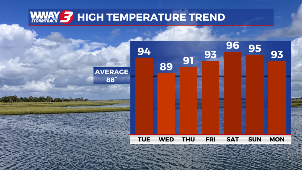
WEATHER DISCUSSION: Atlantic high pressure is in control of the Cape Fear on this Monday evening. It will be partly cloudy… warm and muggy tonight with a low in the upper 70s. A cold front will then approach the region Tuesday and pass through during the evening. Look for sunshine and clouds… hot and humid weather Tuesday with a chance of afternoon showers or thunderstorms with hot and humid highs in the lower to mid 90s. The front passes through Tuesday night with slightly lower heat and humidity Wednesday. An isolated shower or thunderstorm will be possible with partly cloudy skies and highs around 90 Wednesday afternoon. Thursday looks to be mainly rain free with sunshine and scattered clouds and highs around or a little over 90. Friday through Sunday will bring back high heat and humidity with a few mainly afternoon and evening showers and thunderstorms. Otherwise look for highs in the lower 90s Friday then heating up into the middle to perhaps upper 90s for this coming weekend.
WWAY FORECAST:
Today: Sunshine and clouds… hot and humid. A few afternoon showers or thunderstorms possible. High in the lower to mid 90s. Heat index values between 101 and 105 in the afternoon. Breezy southwest winds 15-25 mph.
Tonight: Hit or miss showers or thunderstorms early. Scattered cloudiness. Low in the lower 70s.
Wednesday: Partly cloudy and not quite as hot or humid. High around 90.
Thursday: Partly cloudy skies with temperatures into the lower 90s.
– Meteorologist Jason Korver