Hot and humid weather throughout this week
(WWAY) — Increasing temperatures throughout the week into the holiday weekend.
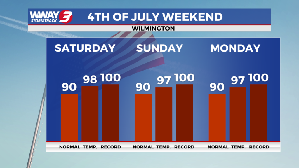
Today will be very warm with abundant sunshine and a few clouds with highs around or a little over 90. High pressure remains in control for middle week with Wednesday bringing mostly sunny skies and rather hot highs in the lower 90s. Our pattern changes late this week as a strong upper-level ridge brings high heat and moderate humidity under rain-free skies. Look for sunshine and a few clouds with highs Thursday in the lower to middle 90s and mid to upper 90s for highs by Friday. Independence Day Saturday will be very hot with plentiful sunshine as highs continue into the upper 90s… with heat indices reaching as high as 110 in the afternoon. By Sunday a piedmont trough could help bring a return to isolated showers or thunderstorms otherwise it will remain very hot and humid with highs again in the upper 90s.
WWAY FORECAST:
Today: Abundant sunshine and a few clouds. A very warm afternoon high around or a little over 90. Winds northeast becoming east at 10-15 mph.
Tonight: Mostly clear skies. Mild and muggy low in the lower 70s.
Wednesday: Mostly sunny and rather hot. High in the lower 90s.
Thursday: Mostly sunny skies with high temperatures into the middle 90s.
-Meteorologist Jason Korver