UNCW plans to use new drones for coastal mapping
WILMINGTON, NC (WWAY) — UNCW will soon become the first university in the southeast to acquire drones for coastal mapping.
The system is supported by a National Science Foundation Major Research Instrumentation Grant of nearly $851,000.
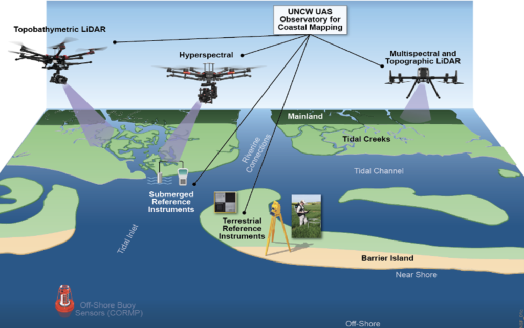
UNCW says the drones will equip them with state-of-the-art instrumentation that can study the coastal ecosystem in unprecedented ways from both the air and the ground. The sensors will collect valuable visual data as well as infrared and thermal data not seen with the naked eye.
Researchers will be able to better study topics like flooding, barrier island morphology and evolution, coastal water quality and vegetation, harmful algae blooms, wildlife habitats and archaeological and cultural resource identification.
Dr. Pricope, lead principal investigator, said the new drone will build on the university’s expertise and bring research and collaborations that had previously not been possible.
“This acquisition will enable continuation and development of new and diverse interdisciplinary applications of UAS-derived data and provide unparalleled opportunities for student training, professional development and community partnerships,” Dr. Pricope said.
The UNCW UAS Coastal Observatory will be housed at UNCW’s Center for Marine Science in the MARBIONC labs. It will consist of three off-the-shelf, commercial drone platforms equipped with four complementary remote sensors and other instrumentation.
“The advanced instrumentation used in this award exemplifies how the connection between basic research and technology can have practical applications for coastal communities,” UNCW Center for Marine Science executive director Dr. Ken Halanych said. “This type of translational research is what the MARBIONC program is all about.”
The UNCW UAS Coastal Observatory should be fully operational by January 2023. Data collected from the observatory will be available to the public via a UNCW-hosted dashboard.