Warm and dry weather expected today
(WWAY) — Slightly warmer weather today as temperatures increase for the weekend.
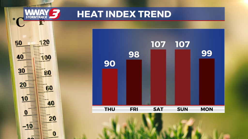
A high pressure remains our main weather feature today bringing sunshine and scattered clouds with dry and warm afternoon highs around 90. Subtropical high pressure strengthens Friday with hot and humid weather returning as highs reach the lower 90s along with a slight chance of afternoon showers or thunderstorms. This weekend will bring high heat and humidity with a few mainly afternoon and evening showers and thunderstorms… especially Sunday. Look for sunshine and clouds with highs both Saturday and Sunday in the middle to upper 90s and heat indices above 105 likely leading to heat advisories for the region. If you have weekend outdoor plans… take plenty of breaks and drink lots of water to stay hydrated. Early next week high pressure will try and build down from the north leading to slightly lower daytime temperatures. Monday features partly cloudy skies with a slight chance of afternoon showers or thunderstorms and highs in the lower 90s. Next Tuesday and Wednesday will bring hot and humid weather again with highs in the lower to mid 90s and mostly sunny skies with rain free weather.
WWAY FORECAST:
Today: Sunshine and scattered clouds. Dry and very warm high around 90. Winds east becoming southeast at 5-10 mph.
Tonight: Fair skies. Warm and more humid with a low in the lower 70s.
Friday: Humid and becoming hot. Sunshine and clouds mixed with isolated afternoon showers or thunderstorms. High in the lower 90s. Heat index values in the upper 90s to near 100 in the afternoon.
-Meteorologist Jason Korver