Hurricane Hermine making landfall in Florida, headed for southeast NC
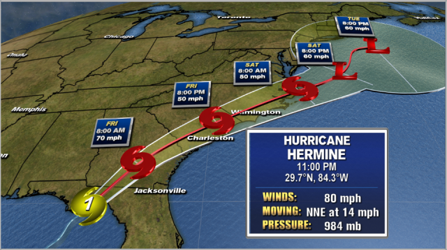
WILMINGTON, NC (WWAY) — Hurricane Hermine is making landfall near Apalachicola Bay with maximum sustained winds of around 80mph. As the storm continues on it’s NE track up the coast it is expected to be downgraded back to a tropical storm when it arrives in our area Friday. Tropical storm warnings are now posted along the Georgia, South Carolina and portions of southeast North Carolina up to Surf City.
Get the latest information in the WWAY Hurricane Center
Heavy rain and gusty winds to tropical storm force are likely in the viewing area tomorrow with the peak coming late afternoon into the night. Residents are urged to prepare for the possibility for winds that could cause power outages, and some limbs and some trees to come down. If you live in a flood prone area, monitor water levels during the storm. Along the coast, the surf will become rough, rip currents will be likely and there could be some coastal flooding and some beach erosion. The threat for isolated tornadoes will also accompany Hermine’s arrival.
The good news is this will be a relatively fast moving storm and will be gone by most of the upcoming Labor Day weekend.


Leave a Reply