Cooler temperatures continue today
(WWAY) — Temperatures remain below average today as temperatures barely reach into the 70s.
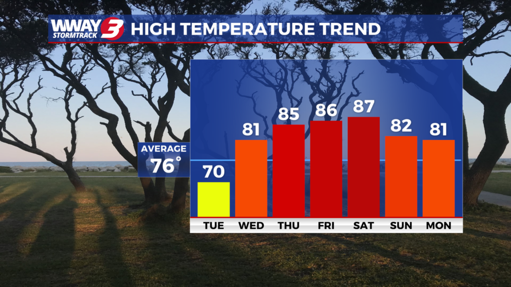
High pressure moves across the region today bringing sunny skies and continued pleasant weather with a high around 70. The high pressure continues to dominate but shifts offshore Wednesday leading to mostly sunny skies and warmer highs around or a little over 80. More dry weather lingers Thursday with a good deal of sunshine and warm highs in the mid 80s. Not much change Friday with plentiful sunshine continuing along with a few clouds and warm highs in the mid to upper 80s. A cold front will approach and then move into the Carolinas this coming weekend bringing a chance of much needed showers or a thunderstorm… mainly Saturday night and Sunday. Highs will reach the very warm upper 80s Saturday before dropping back into the lower 80s Sunday. Low rainfall totals continues over the next 7 days… confined to this upcoming weekend when a tenth to a quarter inch of rain is possible. Unfortunately… it will not be enough to relieve the ongoing severe drought in place.
WWAY FORECAST:
Today: Sunny skies. A pleasant afternoon high around 70. Winds northeast becoming southeast at 5-10 mph.
Tonight: Fair skies and cool. Low around 50.
Wednesday: Mostly sunny and warmer. High around or a little over 80.
Thursday: Mostly sunny skies with temperatures into the middle to upper 80s.
-Meteorologist Jason Korver