Slightly cooler temperatures for today
(WWAY) — After a cold front moved through yesterday, temperatures will rise only into the middle 80s for today.
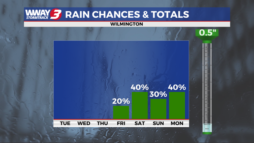
Today will bring partial sunshine and it will be briefly cooler than recent days with a high dropping back into the middle 80s. Wednesday will continue the mainly dry weather with sunshine and clouds mixed. It will start to heat back up with highs in the upper 80s to near 90. By late week… summerlike conditions will strengthen once again as Atlantic high pressure rebuilds with a mixture of sunshine and clouds and highs reaching the low 90s and a slight chance of a shower or thunderstorm… mainly on Friday. Humidity levels will remain high making it feel hotter than the thermometer indicates during the afternoon hours. Another front will approaches the Carolinas but fade this weekend. The deeper moisture flowing in will combine with a piedmont trough to bring a better chance of showers and thunderstorms Saturday and Sunday with highs in the lower 90s.
WWAY FORECAST:
Tuesday: Partly sunny and a little cooler. High in the middle 80s. Winds east becoming southeast at 5-10 mph.
Tuesday Night: Partly cloudy skies. Mild and muggy low around 70.
Wednesday: Sunshine and clouds mixed. Heating up again with a very warm and humid high in the upper 80s to near 90. Heat index values in the afternoon reaching the lower 90s.
Thursday: Partly sunny skies with temperatures into the lower 90s.
-Meteorologist Jason Korver