History with ‘Hud’: The 200-year, 3,000-mile history of the Intracoastal Waterway
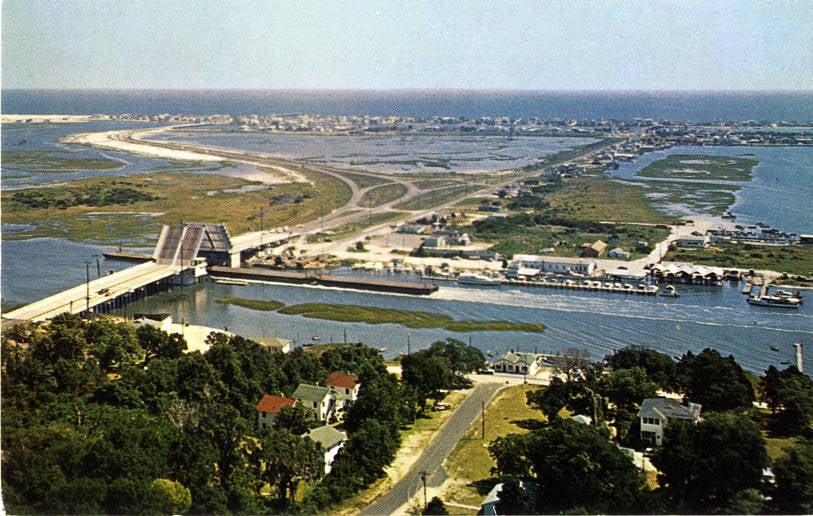
WILMINGTON, NC (WWAY) — If you’ve ever been to a beach along the Cape Fear coast, you likely crossed the Intracoastal Waterway to get there. Ocean Isle Beach, Holden Beach and Oak Island are among the many beach towns only accessible by bridges crossing the mostly man-made waterway, which locally runs from Topsail Island, past Wilmington and to the North Carolina-South Carolina border.
But the familiar feature spans a greater distance and time period than most people realize.
The initial idea for the Intracoastal Waterway (intra-, not inter-) began in the early 1800s, when U.S. Secretary of the Treasury, Albert Gallatin, presented the concept to President Thomas Jefferson for a protected north-south waterway. Gallatin’s proposal was for the channel be constructed between Massachusetts and Georgia (at that time, the southern-most state) to allow boats to navigate great distances up and down the east coast without having to face the treacherous open Atlantic Ocean waters. Gallatin’s full 10 year, $20 million federal-funded plan was rejected. But the U.S. Army Corps of Engineers still carried out a series of surveys and construction began on portions with the help of private investors.
Several years later in 1824, the General Survey Act took place, detailing the rivers, harbors and sounds providing a base for the Intracoastal Waterway to form. But a slow start to the project and the breakout of the Civil War led to a lengthy delay in completion. It wasn’t until after the railroad boom in the late 1800s gave way to a surge in barge transportation that attention returned to the idea of a continuous waterway along the east coast.
In 1913 the U.S. Army Corps of Engineers submitted a report to Congress for a new phase from Beaufort, North Carolina to southern Florida. The report recommended a 10 foot depth for the 925 miles of waterway. This phase was completed over six years at an estimated cost of $31 million.
When fighting broke out again during World War One and World War Two, the waterway quickly proved its importance. The new passage was used to transport cargo and avoid German submarines in the Atlantic. It was also around this time Major William Arthur Snow was overseeing a portion of the project near Carolina Beach. Following its completion, the land cut in this section of the Intracoastal Waterway was deemed ‘Snow’s Cut’. (Major Snow went on to be buried in Arlington National Cemetery.)
In all, North Carolina is home to 300 miles of the waterway, which was completely finalized in 1949. Originally planned to be a continuous waterway from Massachusetts to Texas, a section across the northern part of Florida was never constructed. So the waterway made of natural channels and man-made pathways ended up being a two part feature – the Atlantic Intracoastal Waterway, running down the east coast from Massachusetts to southern Florida, and the Gulf Intracoastal Waterway, from Florida over to Brownsville, Texas.
The 3,000 mile waterway is no longer relied on as heavily for day-to-day transportation, instead being used more for recreational boating. But the waterway looks to remain a steadfast feature for generations to come.