Showers increasing late morning
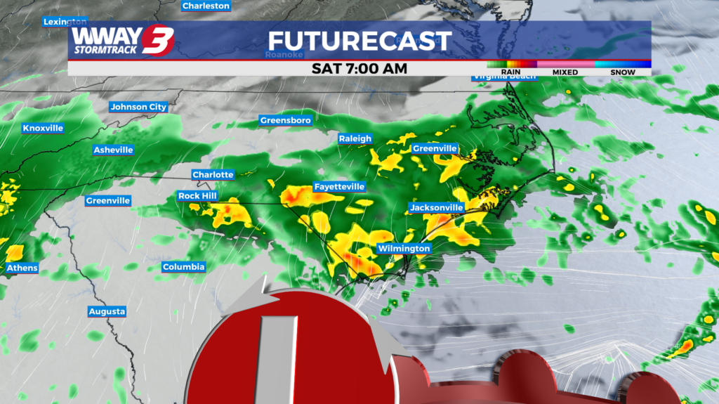
(WWAY) — A line of showers is moving east towards the Cape Fear this morning as more rain is expected this weekend.
A few showers are possible mainly this morning as another area of moisture moves northeast into the eastern Carolinas. We anticipate decreasing cloudiness in the afternoon with a high in the middle to upper 70s. Weak high pressure ridges in from the west Friday bringing partly sunny skies with isolated afternoon showers possible and highs in the lower to mid 70s. A frontal boundary and waves of low pressure will impact the region Friday night into Saturday bringing widespread showers with cooler highs in the upper 60s. Rainfall totals Friday night and Saturday could be healthy… an inch to an inch an a half possible. High pressure builds back in Sunday into Monday bringing a return to dry weather. Look for pleasant highs around or a little over 70 Sunday warming into the mid to upper 70s Monday. Next Tuesday will bring warmer weather with mostly sunny skies and highs around 80.
WWAY FORECAST:
Today: A few showers… mainly in the morning. Gradually decreasing afternoon cloudiness. High in the upper 70s. Winds northwest around 10 mph.
Tonight: Partly cloudy skies. Cooler low in the lower 50s.
Friday: Partly sunny with isolated afternoon showers possible. High in the lower to mid 70s.
Saturday: Widespread showers expected with temperatures into the middle 60s.
-Meteorologist Jason Korver