Near record highs expected for Friday
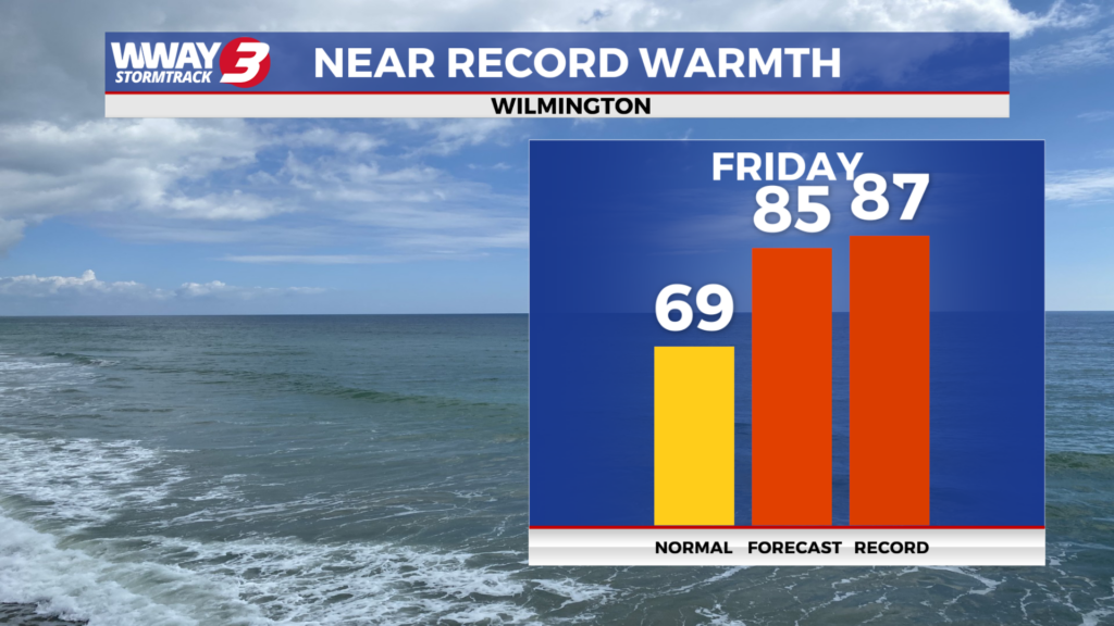
(WWAY) — Temperatures will be soaring into the 80s today just before a cold front moves through tonight.
A few showers are possible tonight as the cold front swings through. However, rainfall amounts look meager with perhaps only a few hundredths of an inch to a tenth of an inch at best.
Saturday night could feature some patchy frost inland with chilly lows in the upper 30s. Sunday looks nice with mostly sunny skies and highs reaching the middle 60s. Early next week the high pressure cell will shift offshore allowing for a nice moderation in temps.
Look for sunshine and scattered clouds Monday with highs in the lower 70s. Plentiful sunshine will follow Tuesday with warmer highs in the upper 70s. Subtropical high pressure remains in charge next Wednesday with highs pushing 80 under sunshine and clouds. With ongoing drought and continued mainly dry weather over the next 7 days, be very careful with flame and follow any local burn bans in place.
WWAY FORECAST:
Today: Mostly sunny skies. Warm high in the lower to mid 80s. Winds southwest around 15 mph.
Tonight: Increasing cloudiness with a few showers possible. Low around 50.
Saturday: Mostly cloudy early… then increasing sunshine. Much drier and cooler with breezy winds. High around or a little over 60.
Sunday: Partly cloudy skies with temperatures into the middle 60s.
-Meteorologist Jason Korver
To view the full 7-day forecast, click HERE.